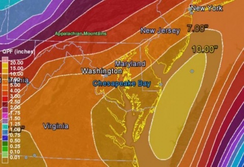
2 PM, Thursday, Oct. 1, 2015: A meteorological meeting of sorts is taking shape along the East Coast this first day of October, and it could spell significant trouble for Sussex County in the days ahead, with a nor’easter and trailing hurricane setting the stage for up to 7 inches of rain, 50 mph winds, major beach erosion and moderate to severe coastal flooding that could strand residents in low-lying areas into next week.
Forecasters with the National Weather Service expect a coastal storm now developing to soak Sussex County from Thursday evening through at least Saturday, dumping torrents of rain, raising tides, and whipping up winds. And that’s just the precursor to a potential brush with a Category 4 storm, as Hurricane Joaquin, with sustained winds of 130 mph near the Bahamas, is forecast to hug the U.S. coastline later this weekend.
The combination of the nor’easter and hurricane, along with a stalled cold front draped along the coast and a strong high pressure system to the north, could mean days of strong onshore winds piling up water along Delaware’s beaches and inland bays, flooding low-lying areas and cutting off access in some places.
No evacuations have been ordered, and no shelters have been designated at this time. However, the Sussex County Emergency Operations Center, which continues to monitor the situation, is cautioning those residents in vulnerable areas to seriously consider relocating to higher ground.
“The safety of our citizens is the No. 1 concern. This could be a significant flooding event that affects Sussex County not just for a few hours, but for several days,” Sussex County EOC Director Joseph L. Thomas said. “There is a lot to be concerned about with the forecast, so the public needs to be prepared now and move, if possible, before flood waters come in.”
The Sussex County EOC encourages residents and visitors to continue monitoring the forecast and conditions as they deteriorate.Sussex County urges those planning to visit the area for the upcoming weekend to carefully monitor conditions and consider delaying their plans. Campers in area parks should also monitor the forecasts, and be prepared to leave if ordered to do so.
While all eyes have been on Hurricane Joaquin, the developing nor’easter, for the moment, has emergency planners most concerned. That storm is expected to drift along the coastline, spreading heavy rains while pushing sea water up onto beaches and into back bays. Areas that historically flood, including Long Neck, Broadkill Beach and Primehook, could see moderate to severe flooding through at least the weekend with tides as much as 3 to 4 feet above normal.
The heaviest weather is expected to begin this evening and last through at least Saturday. After that, the forecast will depend on what track Hurricane Joaquin takes – a more easterly track over the ocean would lessen the effects of wind, rains and flooding; closer to the coast or, in a worst-case scenario, up the Chesapeake Bay could make for potentially disastrous results in the region.
Residents and property owners should take time now to secure loose objects, such as lawn chairs and trash cans, to prevent winds from turning those items into projectiles. Also, residents in low-lying areas should make sure submersible pumps are working and check storm drains to ensure they are clear of debris.
For updates, stay tuned to local television and radio stations, as well as the Sussex County website at sussexcountyde.gov. The public also should monitor the National Weather Service, at www.weather.gov/phi and the National Hurricane Center at www.nhc.noaa.gov for the latest forecasts.
Meantime, Sussex County offers a variety of social media outlets, which are a great resource for up-to-date storm information. Please follow along at: www.facebook.com/SussexCountyDE, www.facebook.com/SussexCountyEOC, and www.facebook.com/SussexCountyEMS on Facebook; and twitter.com/sussexde_govt, twitter.com/SussexCtyDE_EOC, and twitter.com/SussexCoDE_EMS on Twitter.
For more information, please contact the Sussex County EOC’s storm information hotline at (302) 856-7366.
###

