

Georgetown, Del. (3 p.m. Fri., Sept. 22, 2023): A newly named coastal storm could give Sussex County its first brush with tropical weather for the 2023 season, as forecasters expect potentially major shoreline flooding, gusty winds, and soaking rains to overspread the region and last through much of the weekend.
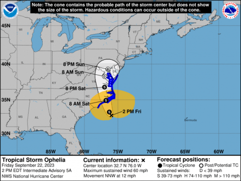
The National Hurricane Center early Friday afternoon officially designated Tropical Storm Ophelia, a center of low pressure off the southeastern United States that is forecast to move up into the Carolinas, then track through the Chesapeake Bay region beginning Friday night before exiting the mid-Atlantic late Sunday. With it, the storm is forecast to bring Sussex County 2 to 4 inches of rain, winds up to 60 mph, significant beach erosion, dangerous rip currents, and moderate to severe flooding in low-lying coastal areas.
No tropical storm warning is in effect for Sussex County or any locales north of Delaware at this time. However, a high wind warning, surf advisory, and coastal flood warning are in effect for portions of Sussex County through late Saturday.
The Sussex County Emergency Operations Center, which is actively monitoring the situation, cautions those in vulnerable areas to be proactive now by securing their property and having a plan in place to relocate in case the need arises.
“Thankfully, this is not a full-fledged hurricane or a long-duration nor’easter event. But there will be some rough weather for the next 24 to 36 hours, so it’s important that residents and visitors – especially people who maybe haven’t experienced a tropical system before – pay attention to the forecast and take some simple, relatively easy steps now to prepare,” Sussex County EOC Director Joseph L. Thomas said. “The public should expect flooding in low-lying areas, maybe some minor wind damage, rough surf, and all those could cause road closures, downed trees, and power outages. Taking a few minutes now to prepare will go a long way in weathering whatever the storm brings.”
Conditions are expected to begin deteriorating this evening and could last through at least Sunday, when the storm should weaken and begin to exit the region. That forecast, though, will depend on how quickly the storm begins to dissipate and where the center of circulation tracks.
Residents, visitors, and property owners should take time now to secure loose objects, such as lawn chairs and trash cans, to prevent winds from turning those items into projectiles. Also, residents and visitors in low-lying areas should relocate vehicles to higher ground, if possible, make sure submersible pumps are working, and check storm drains to ensure they are clear of debris. Areas that historically flood along the Delaware Bay and Inland Bays, including Long Neck, Broadkill Beach and Primehook, could see moderate to severe flooding driven by prolonged northeast winds through at least Sunday, as tides may run up to 3 feet above normal.
For updates, stay tuned to local television and radio stations, as well as the Sussex County website at www.sussexcountyde.gov. The public also should monitor the National Weather Service, at www.weather.gov/phi and the National Hurricane Center at www.nhc.noaa.gov for the latest forecasts.
Meantime, Sussex County offers a variety of social media outlets, which are a great resource for up-to-date storm information. Please follow along at: www.facebook.com/SussexCountyDE, www.facebook.com/SussexCountyEOC, and www.facebook.com/SussexCountyEMS on Facebook; and www.twitter.com/sussexde_govt, www.twitter.com/SussexCtyDE_EOC, and www.twitter.com/SussexCoDE_EMS on X (formerly Twitter).
###